Laid off from Walker in 1887. Length, 24m.; breadth, 12m.; area square mile, 288. Named after Major Francis Langhorne Dade, U.S.A., who was killed by the Indians in Florida, December, 1835.
Lookout Creek is the only stream of any importance.
The soil is fertile, producing with little labour abundant crops of corn, wheat, rye, and oats.
The mountains are Lookout and Raccoon.
TRENTON is the County site, 240 miles from Milledgeville.
The climate is cold in winter, but delightful in the summer. The instances of longevity with which we are acquainted are the following: Mrs. Cartwright, 80; Mrs. Carr, 80; Mr. R. Cox, 80; Mr. Asbury, 100.
The mineral resources of the county are great, and large quantities of bituminous coal are found in the mountains. It also abounds with caves; and it is thought that within its limits are more than fifty Indian mounds.
Extracts from the Census of 1850. --- Dwellings, 421; families, 421; white males, 1,246; white females, 1,286. Total free population, 2,532; slaves, 148. Deaths, 30. Farms, 235; manufacturing establishments, 4. Value of real estate, $240,220; value of personal estate, $151, 443.
The Legislature of 1849 made an appropriation of $3,500 to construct a road over the Lookout Mountain.
Among the persons who first settled this county were, J.B. Perkins, Joel Hulsey, James Stewart, Howell Tatum, John Guinn, Isam Cole, A. Hale, Wm. Highs, T. L. Tanner, A. B. Hannah, Jacob McCollum, W. Hulsey, G. Stephens, Z. O'Neal, L. Hendricks, Jesse Carroll, Jeremiah Pace, M. Cunningham, M. Morgan, William Morgan, Jacob Sitton, W. H. Taylor, R. L. Taylor, Davis Killion, Daniel Killion, Alfred Garner, James M. Hall, Leroy Sutton, George Sutton.
Laid off from Early in 1823; part set off to Thomas in 1825. It received its name from Commodore Stephen Decatur. Length, 36 m.; breadth, 25 m.; area square miles, 900.
The Flint River runs through the county, and the Chattahoochee forms its western boundary.
Spring Creek is a considerable body of water. There are several other streams, viz., Musquito, Willocoochee, &c.
In various parts are excellent tracts of land. Between the Flint and Chattahoochee rivers is a pine barren, with some fertile spots, which are well calculated for the growth of cotton and corn, the soil being silicious.
The climate is temperate and pleasant.
BAINBRIDGE is the county town, situated on the east side of the Flint River, on the beautiful bluff, 190 miles from Milledgeville.
Fort Scott is below Bainbridge, on the Flint River.
Attapulgus is 12 miles southeast of Bainbridge.
Extract from Census of 1850. --- Dwellings, 898; families, 898; white males, 2,391; white females, 2,227; free coloured males, 3; free coloured females, 2. Total free population, 4,623; slaves, 3,639. Deaths, 92. Farms, 491; manufacturing establishments, 2. Value of real estate, $805,018; value of personal, $1,970,631.
Among the original settlers of this county may be named the following, viz.: G. Mitchell, Wm. Martin, Wm. Donaldson, Joel Darsey, John Darsey, W. Williams, H. Ingraham, B. Crawford, James Griffin, M. Hardin, James Brown, Samuel Cherry, Wm. Powell, Samuel Williams, Daniel O. Neal, Hiram Atkinson, James T. Neal, Wm. Forson, M. Kelly, Wm. Hawthorn, John White, John Jones, Duncan Ray, Edmund Herring, Joshua Proctor, William Whigham, Elias McElvan, William Powell, Philip Pitman, John Donaldson, R. B. Douglas, Abner Bishop, Jeremiah Slade, Wm. Chester, Captain Parham, R. Strickling, J. Saunders, G. G. Gaines.
THIS county is remarkable for its numerous caves or lime-sinks.
Dr. Cotting, who made a geological survey of this portion of the State, has kindly furnished us with the facts: ---
"Decatur abounds with what are called lime-sinks. Some are filled with water, others are empty. Some have streams passing through the bottom, and communicating with the river. The walls of these caverns are lined with slaty limestone, in which there is a quantity of marine organic remains.
"At Curry's Mills, neat the church, is a large sink or depression. The rim of the crater is nearly circular, being 666 feet; depth, 102 feet.
"Sixteen miles from Bainbridge is a cavern, explored to the distance of eighty-three feet, --- a small stream runs through it.
"Three miles east of Flint River is a large fissure, one hundred yards long; breadth, 10 feet; depth, 30 feet."
One-half of a mile southeast of Black Creek, Dr. Cotting found fragments of large tusks, and other bones of the zeuglodon.
Laid out in 1822, and named after the Baron De Kalb, who fell in defence of American Freedom at the battle of Camden, South Carolina, on the 19th of August, 1780. Length, 25 m.; breadth, 19 m; area square miles, 475.
The Chattahoochee is the chief river. The creeks are, Nancy's, Peach-Tree, Utoy, &c.
DECATUR is the county town, ninety-five miles north west of Milledgeville.
Atlanta has had a growth unexampled in the history of the South. It is the point at which the Western and Atlantic, the Macon and Western, and the Georgia railroads, connect.
To J. Norcross, Esq., we are indebted for the following statement relating to Atlanta; --
Population of Atlanta not previously known, but placed by none under 4,500, and still increasing.
The number of stores, exclusive of retail liquor-shops, in the city is 57.
Large cotton warehouses, 4.
Amount of goods sold from 15th December, 1850, to 15th December, 1851, was $1,017,000.
The amount of Georgia and Tennessee produce sold, exclusive of cotton, during the same time, $406,000.
The amount of goods sold in the month of October, 1851, $108,000.
Amount of cotton received and sold from December, 1850, to December, 1851, 35,500 bales.
Amount of money advanced by bank agents to buyers in Atlanta and neighboring villages, and bills drawn against cotton shipped in Augusta, Savannah, Charleston, and New-York, $1,250,000,---making, in round numbers, exchange or mercantile transactions over $2,500,000.
Nor does his include large quantities of Georgia and Tennessee produce, received and sold here by the owners, the large portion of which would probably go into stores here, were there any banking or other suitable accommodations for advancing on the same.
There is in this city one steam flouring mill, investment $35,000,---the operation of which may be placed at $150,000 per annum. One iron foundry and machine shop--cash operations, $20,000 per annum. Three carriages and wheel wright shops. Two large tanneries. One large shoemaking establishment. Two large tanneries and shoe establishments in the course of construction. In addition to the Georgia Railroad and State machine shops, which employ large numbers of workmen, one car-shop is now going up as a private enterprise---investment, $30,000.
WINSHIP'S ESTABLISHMENT.---The main building of this extensive establishment is 200 feet by 40 feet; a wing at one end, 24 feet by 32 feet for engine; a wing near the centre, 20 by 40 feet, for black-smith's shop. Engine, 25 horse-power; planning machines, 3; circular saws, 4; tenoning machine, 1; sash ad moulding machine, 1; wood turning lathe; 1; bolt-cutting machine, 1; drill press, 1; number of hands employed, 40. Chief business, making railroad cars. Capital, $20,000.
ATLANTA TANNING COMPANY.---Proprietors, Alexander & Orme. Capital, $20,000. Propelled by steam. Dimensions of building, 50 feet by 80, with a wing 25 by 50; ;two stories high. Hands employed, 10. Hides handled by machinery. Connected with this establishment are a grist-mill and a patent circular saw-mill, lathe and shingle machine.
ATLANTA MACHINE COMPANY.---Capital employed, $5,000; number of hands, 12; amount of work done per annum; $12,000; dimensions of building, 160 X 40 feet.
Stone Mountain and Lithonia, small places, are on the Georgia Railroad.
Extract from the Census of 1850.---Dwellings, 1,792; families, 1,794; white males, 5,704; white females, 5,668; free coloured males, 9; free coloured females, 23. Total free population, 11,404; slaves, 2,924. Deaths, 118. Farms, 1,019; manufacturing establishments, 45. Value of real estate, $1,669,810; value of personal estate, $1,721,560.
Among the early settlers of this county were: WILLIAM JACKSON, JAMES MONTGOMERY, JOHN R. BROOKS, Wm. EZZARD, W. M. HILL, JOSEPH HEWEY, STEPHEN MAYS, R. CONE, J. M. SMITH, Wm. DAVID, MASON SHEWMAKE, JOHN SIMPSON, AMOS TOWERS, JOHN W. FOWLER, EDWARD JONES, ANDREW JOHNSON, JOHN TURNER, J. P. CARR, JAMES W. REEVES, COLONEL MURPHY, GEORGE CLIFTON, JAMES JONES, JESSE LANE, L. JOHNSTON, Wm. TERRELL, GEORGE BROOKS.
The climate is healthy. Instances of longevity are numerous, JOHN BIFFLE died at 106. D. GREENE, 90; Wm. TERRELL, 90; MR. BROOKS, 92; Wm. SUTTLES died in 839, aged 108. He was possessed of great physical strength and had been a soldier of '76. At his death an estimate of his descendants was made, and it amounted to 300 persons. His wife, MARGARET, 104 years old, died in June, 1839. For seventy years she had been a member of the Baptist Church. CHARLES ISOM and JAMES BURNES, both 90, are now living. Wm. REEVES died at 87.
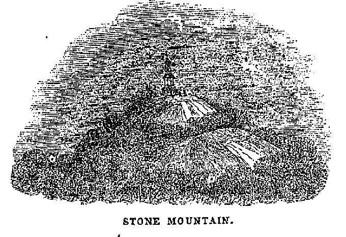
The Stone Mountain is the county, of which we have seen many descriptions; but the following, taken from the Macon Telegraph, of April 3, 1830, we consider the most accurate:--
The Stone Mountain is a huge solid peak of solitary rock, three thousand feet in height, and six or seven miles in circumference. The finest view of this stupendous pyramid is obtained from the eastern side. Seen from this point at a distance, it has the appearance of a large dark cloud streaked with thunder and lightning. Approach it neared, and its figure and consistence become distinguishable; you see the bold, naked rock, nearly globular in form of a darkish gray colour. On climbing it, the shrubs and bushes are scattered so thinly over its sides among the crevices, that it appears nearly bald. About half way up to te right of your path is pointed out a small tuft of shrub cedars and oaks, designated as the Buzzard's Roost, from the number of those birds hovering about the spot.
About a quarter of a mile from the top are seen the remains of a fortification that formerly extended around and defended every accessible point leading to the summit, the only entrance being through a natural passage under a large rock, where only one person could enter at a time, and that by crawling on all fours. The whole length of the wall at first was probably a mile, breast high on the inside, and constructed of loose fragments of the rocks. On reaching the summit, you have a beautiful and extensive view of the country. The top presents an uneven surface, nearly flat, of an oval shape, two or three hundred yards in width, and about twice that in length.
Many hollows are observable in the winter and spring, filled with water, and occasionally little patches of soil, where various shrubs and herbs luxuriate. On the eastern side, some distance from the top, is a little grove called the Eagle's Nest. Adjoining it, among the broken fragments, are a number of frightful caverns, called the Lion's Den, the Panther's Hole, &C.
From the summit you may ramble down the arch in any direction for several hundred yards, without danger.
A pathetic story is told of a couple of hounds that a year or two ago followed their owners to the top of the mountain, and in performing their gambols round the edge of the precipice, had got too far down to be able to get back. One slid immediately over, and was dashed to pieces on the rocks below, not a whole bone being left, in his skin; the other held to the rock for two days, howling piteously, but at last became exhausted, fell, and shared the fate of his companion.
BOUNDARIES described in the Lottery Act of 1821. Part added to Pulaski, 1826; a part to Lee, 1827. Named after Colonel John Dooly, who was murdered by the Tories in 1780. Length, 35m.; breadth, 32m.; area square miles, 1,120.
The chief stream is the Flint River. The creeks are, Pennahatchee, Hogcrawl, Lampkin's Limestone Cedar, &c.
The face of the country is level; much of the land is productive. Lands which a few years ago were considered worthless, now command high prices.
VIENNA is the county town, situated on the waters of Pennahatchee Creek, distant from Milledgeville ninety-five miles.
Drayton is a mile and a half from Flint River.
Traveller's Rest is in the northwest corner of the county.
The climate is temperate. Remote from the water-courses, the country is regarded healthy. The cases of longevity with which we are acquainted are the following:---MR. WADSWORTH died at 103; MRS. NAPIER, aged 100; MRS. WADSWORTH, aged over 100; and Mrs. Bradshaw, aged over 80, were all alive a few years since.
Extract from the Census of 1850.---Dwellings, 962; families, 962; white males, 2,844; white females, 2,736; free coloured males, 4; free coloured females 2. Total free population, 5,586; slaves, 2,775. Deaths, 110. Farms, 663; manufacturing establishments, 8, Value of real estate, $1,106,253; value of personal estate, $1,721,560.
Dade County transcribed by Renee Miranda - November, 2003.
Decatur County transcribed by Renee Miranda - November, 2003.
DeKalb County transcribed by: Brenda Pierce (ltlbit@mindspring.com 1/18/2004)
Dooly County transcribed by: Brenda Pierce (ltlbit@mindspring.com 1/18/2004)
First put online 4 Jan 2004.
 If you have resources for Georgia, please e-mail me at Tim Stowell
There were 1960 visitors to our previous site from 25 Jun 2004 to 11 Aug 2011.